The Importance of Satellite Images in Today’s World
Introduction
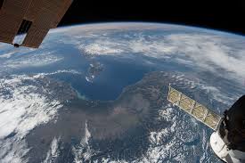
Satellite images have become a crucial tool for researchers, governments, and organizations worldwide in analyzing environmental changes, conducting urban planning, and responding to natural disasters. In an age where data is key to making informed decisions, the role of satellite imagery has become increasingly relevant, offering unique insights that are impossible to gather solely from the ground.
Recent Developments in Satellite Imaging
In recent years, advancements in satellite technology have significantly improved the quality and accessibility of satellite images. Notable organizations, such as NASA and private companies like Planet Labs and Maxar Technologies, have launched multiple satellites equipped with high-resolution imaging capabilities. These satellites are able to cover vast areas with remarkable detail, enabling better monitoring of both natural and human-made phenomena.
Applications of Satellite Images
1. Climate Change Monitoring: Satellite images are instrumental in tracking environmental changes. They provide invaluable data on deforestation, glacier retreat, and urban sprawl, helping scientists and policymakers understand the impacts of climate change and devise appropriate responses.
2. Disaster Management: After natural disasters like hurricanes, earthquakes, or floods, satellite imagery offers critical information for damage assessment and recovery efforts. Authorities utilize these images to coordinate rescue operations and allocate resources efficiently.
3. Agriculture and Land Use: Farmers and agricultural organizations are increasingly relying on satellite data to inform planting schedules, monitor crop health, and assess land use. This data-centric approach helps enhance productivity and sustainable farming practices.
The Future of Satellite Imaging
With the rapid pace of technological innovations, the future of satellite imaging looks promising. The development of smaller, more efficient satellites—often termed ‘CubeSats’—is making it more economical to deploy satellite technology. Additionally, artificial intelligence and machine learning algorithms are being integrated to process vast amounts of data, providing real-time monitoring and predictive analytics.
Conclusion
In conclusion, satellite images play a vital role in transforming data into actionable insights. As the demands of society increase, leveraging satellite technology can prove essential in addressing challenges related to climate change, disaster response, and resource management. The significance of satellite images is poised to grow, making this a key area for continued research, investment, and technological development.


